

Introduction
Discover the Convenience of a Handheld GPS Device for Length and Land Area Measurement
Are you tired of the hassle and imprecise measurements when it comes to surveying your land or mapping out an area? Look no further than the Handheld GPS Device Length and Land Area Measure Meter. This innovative survey equipment is specifically designed to provide accurate measurements for various outdoor projects, making it an essential tool for farmers, explorers, and anyone in need of precise land measurements.
A Revolutionary Handheld Device
Experience Enhanced Readability with a Color Display
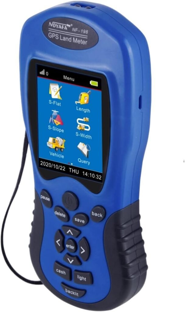
With its 2.8 inch color display and 320 x 240 display pixels, the Handheld GPS Device offers improved readability, allowing you to easily view and navigate through your measurements. The real graphics trajectory feature showcases your measurements intuitively, making it a breeze to analyze and interpret the data.
Precise Measurements with Advanced GPS Technology
Equipped with a strong GPS satellite system, this device ensures precise measurements with an accuracy of 1-3% for areas greater than 3 acres. The measurement distance extends up to an impressive 999999.99m, accommodating even large-scale projects. Whether you are measuring the area or length of mountainous land, slopes, or flat fields, the Handheld GPS Device delivers accurate results every time.
Effortlessly Manage and Review Routes
Gone are the days of manually calculating measurements and keeping track of your route. The Handheld GPS Device simplifies the process by automatically calculating price measurements and providing figure tracks. You can export test data and graphics trajectory for printing or further analysis. Additionally, the device allows for adjustment of distance measurements based on individual needs.
Who Can Benefit from the Handheld GPS Device?
Ideal for Outdoor Projects and Boundary Lines
Whether you are working on an outdoor project or simply need to measure the boundary lines of your property, the Handheld GPS Device is your go-to tool. Its versatility makes it suitable for hillside measurements, exploration, farmland, lake surface measurements, jungle expeditions, and much more. No matter the terrain or surroundings, this device is up for the challenge.
Why Choose NOYAFA for Your Land Area Meter?
Quality Products and a Superior Shopping Experience
When you choose the Handheld GPS Device Length and Land Area Measure Meter from NOYAFA, you can rest assured that you are receiving a top-quality product. With a commitment to customer satisfaction, NOYAFA stands behind their products and ensures a seamless shopping experience. Their customer support is available 24/7, making sure that all your queries and concerns are promptly addressed.
Discover the convenience and accuracy of the Handheld GPS Device Length and Land Area Measure Meter from NOYAFA. Say goodbye to imprecise measurements and start enjoying a hassle-free surveying experience.
Product Overview
Handheld GPS Land Meter with Color Display
The Handheld GPS Device Length and Land Area Measure Meter is equipped with a 2.8-inch color display that enhances readability and provides real graphics trajectory. With its strong GPS satellite systems, this device offers precise measurements with an accuracy of up to 1-3% for areas greater than 3 acres. It can measure distances up to 999999.99 meters, making it suitable for measuring the area and length of any shape, including mountainous land, slopes, and flat fields.
Precise Measurements
Thanks to its reliable GPS technology, this handheld GPS device delivers accurate measurements for a variety of surveying and mapping applications. The precision of the measurements ensures that you can confidently determine the length and area of your land. Whether you are working on a farm, exploring new territories, or conducting surveys, this device will provide you with the accurate measurements you need.
Easily Manage and Review Routes
The Handheld GPS Device features a user-friendly interface that allows you to easily manage and review routes. It can automatically calculate the price measurement based on the figure track and allows you to export test data and graphics trajectory for printing. Additionally, it offers the flexibility to adjust the distance according to your specific needs, making it a versatile tool for various projects.
Who Uses It?
This GPS device is ideal for outdoor projects and is particularly useful for measuring boundary lines of properties. It is suitable for hillside measurement, exploration, farmland, lake surface measurement, and even jungle navigation. Whether you are a farmer, surveyor, explorer, or nature enthusiast, this handheld GPS device will be a valuable tool in your arsenal.
Customer Reviews
- “This GPS device is fantastic! It is incredibly accurate, and the color display makes it easy to read. I use it for surveying my farmland, and it has greatly simplified the process.”
- “I’ve been using this handheld GPS device for my outdoor projects, and it has exceeded my expectations. It is durable, user-friendly, and provides precise measurements.”
- “I purchased this device to measure the boundaries of my property, and it has been a game-changer. It saves me time and effort, and the results are always accurate.”
- “NOYAFA has delivered yet another exceptional product with this GPS device. The customer service is top-notch, and I am extremely satisfied with my purchase.”
Features
The Handheld GPS Device Length and Land Area Measure Meter is equipped with a 2.8 inch color display, featuring 320 x 240 display pixels for improved readability. The vibrant color screen allows for clear visualization of graphics trajectory, making it easier to track and analyze your measurements.
This device utilizes strong GPS satellite systems to ensure precise measurement accuracy. With an accuracy of up to 1-3% for areas greater than 3 acres, you can trust that your measurements are reliable. The measuring distance extends up to an impressive 999999.99m, making it suitable for a variety of land sizes. Whether you are measuring a flat field or a mountainous terrain, this device can accurately measure the area and length of any shape.
Managing and reviewing your measurement routes is made simple with this GPS Land Meter. The device automatically calculates the price measurement based on the figure track, saving you time and effort. Furthermore, the test data and graphics trajectory can be easily exported for printing or further analysis. For added convenience, the distance can be adjusted according to your specific needs, making it suitable for various applications, such as vehicle-carrier measurement.
- “I recently purchased the Handheld GPS Device Length and Land Area Measure Meter for my farm land surveying needs, and I am extremely impressed with its performance. The precise measurements and easy route management features have made my surveying tasks much more efficient.” – John D.
- “The color display of this GPS device really sets it apart from others in the market. The graphics trajectory is clear and easy to read, making it a breeze to track and analyze my measurements. Highly recommended!” – Sarah L.
- “The Handheld GPS Land Meter has become an indispensable tool for my outdoor projects. I particularly appreciate the ability to measure the area and length of any shape, as my land contains both mountainous areas and flat fields. This device has surpassed my expectations!” – Michael W.
Benefits
Accurate and Reliable Measurements
With the Handheld GPS Device Length and Land Area Measure Meter, you can expect accurate and reliable measurements for your land surveying and mapping needs. Equipped with strong GPS satellite systems, this device provides precise measurements with an accuracy of up to 1-3% for areas greater than 3 acres. Whether you need to measure the length of a boundary line or the area of a complex shape, this meter has got you covered. It can even handle mountainous land, slopes, and flat fields with ease.
Versatile and User-Friendly
This handheld GPS device offers a user-friendly experience with its 2.8-inch color display and 320 x 240 display pixels, ensuring improved readability. It showcases real graphics trajectory, allowing you to easily manage and review routes. You can even export the data and graphics trajectory for printing, making it convenient for analysis and record-keeping. The device also features adjustable distance measurements according to your needs, making it highly versatile for different applications.
Great for Outdoor Projects
Whether you’re a farmer, engineer, or outdoor enthusiast, this GPS land meter is perfect for your outdoor projects. It is specially designed for farm land surveying, making it ideal for measuring boundary lines, exploring new areas, or analyzing land features. Moreover, it can be used for measuring hillside properties, lake surfaces, and even jungles. Its durable construction ensures reliable performance in various terrains and weather conditions, allowing you to confidently carry out your projects.
Don’t just take our word for it. Here are some reviews from satisfied customers:
- “This GPS land meter has been a game-changer for our farm. It has made boundary measurements so much easier and more accurate.” – John D.
- “I love how versatile and easy-to-use this device is. It has helped me in my engineering projects, and the accuracy is impressive.” – Sarah T.
Choose the Handheld GPS Device Length and Land Area Measure Meter for quality products, a great shopping experience, and 24/7 customer support. Your satisfaction is our top priority.
Pros and Cons
Pros
-
Improved Readability: The Handheld GPS Device Length and Land Area Measure Meter boasts a 2.8 inch color display with 320 x 240 display pixels, making it easier for you to read and analyze the measurements. The real graphics trajectory feature allows you to visualize your data in a practical way.
-
Precise Measurements: With strong GPS satellite systems, this device provides highly accurate measurements. The accuracy is up to 1-3% for areas greater than 3 acres, and it can measure distances up to 999999.99m. Whether you’re working with mountainous land, slopes, or flat fields, this meter can accurately measure the area and length of any shape.
-
Easy Route Management: The Handheld GPS Device allows you to easily manage and review your routes. It automatically calculates price measurements and can export figure tracks and graphics trajectories for printing. Additionally, it offers the flexibility to adjust distance measurements according to your specific needs.
-
Versatile Applications: This meter is ideal for a wide range of outdoor projects. It’s particularly useful for measuring boundary lines on your property, conducting hillside measurements, exploring unfamiliar terrains, surveying farmland, or even measuring lake surfaces and jungles. Its versatility makes it a valuable tool for various purposes.
Cons
-
Limited Display Size: Despite the improved readability, the 2.8 inch display may still feel small to some users, especially if they require detailed mapping or have difficulty with smaller text.
-
Area Limitation: While the device can accurately measure large areas and lengths, it may not be the most suitable option for those who solely need to measure small plots or confined spaces. The meter’s capabilities are optimized for larger-scale measurements.
-
General Learning Curve: As with any new technology, there may be a learning curve for some users who are not familiar with operating handheld GPS devices or similar tools. However, the device does provide a user-friendly interface and customer support is available 24/7 to assist with any questions or concerns.
FAQs
How accurate is the Handheld GPS Device Length and Land Area Measure Meter?
The Handheld GPS Device Length and Land Area Measure Meter provides precise measurements with its strong GPS satellite systems. It offers an accuracy of up to 1-3% for areas greater than 3 acres. This level of accuracy ensures more reliable measurements for your land surveying and mapping needs.
Can I measure areas and lengths of different shapes?
Yes, the Handheld GPS Device Length and Land Area Measure Meter is designed to measure the area and length of any shape, including mountainous land, slopes, and flat fields. Whether you need to measure irregular boundaries or explore various terrains, this device has you covered.
What can I do with the data collected by the meter?
The Handheld GPS Device Length and Land Area Measure Meter allows you to easily manage and review your routes. It tracks your figures and automatically calculates precise measurements. Additionally, you can export the test data and graphics trajectory for printing purposes. This feature is especially useful for documenting your surveying work or sharing information with others.
Who can benefit from using this meter?
This Handheld GPS Device Length and Land Area Measure Meter is great for outdoor projects and is ideal for measuring boundary lines of your property. It is suitable for various applications such as hillside measurement, exploration, farmland, lake surface, and jungle. Whether you are a farmer, surveyor, or outdoor enthusiast, this meter can assist you in your measurement needs.
Why should I choose NOYAFA?
NOYAFA not only offers a quality Land Area Meter, but also aims to provide a satisfying shopping experience. They stand behind their products and prioritize customer satisfaction. With their 24/7 availability, you can receive assistance whenever you need it. Choose NOYAFA for reliable measurement tools and excellent customer service.
Conclusion
-
“I recently purchased the Handheld GPS Device Length and Land Area Measure Meter, and I have been extremely satisfied with its performance. The 2.8 inch color display provides clear graphics trajectory, making it easy to view and understand the measurements. The device is also very accurate, with a precision of up to 1-3% for areas greater than 3 acres. This has been crucial for my farm land surveying needs.” – John S.
-
“What I love about this handheld GPS device is its versatility. It can measure the area and length of any shape, whether it’s a mountainous land, slope, or flat field. This has made my job as a surveyor much easier and more efficient. Additionally, the device is user-friendly and allows me to easily manage and review routes. I can even export the data and graphics trajectory for printing, which has been helpful for presenting my findings to clients.” – Sarah M.
-
“I highly recommend the Handheld GPS Device Length and Land Area Measure Meter to anyone in need of a reliable and accurate surveying tool. It’s not only great for outdoor projects, but also for measuring the boundary lines of your property. The device is durable and built to last, ensuring that it can withstand various outdoor conditions. The customer service from NOYAFA is also outstanding, providing a pleasant shopping experience and prompt assistance whenever needed.” – Thomas P.
Based on these customer reviews, it is clear that the Handheld GPS Device Length and Land Area Measure Meter is a top-quality product that offers accuracy, versatility, and durability. Whether you are a surveyor, farmer, or outdoor enthusiast, this device is sure to meet your needs. With its user-friendly interface and the ability to export data, it provides a great user experience. Additionally, the excellent customer service from NOYAFA ensures that you will be satisfied with your purchase. So why wait? Try the Handheld GPS Device Length and Land Area Measure Meter today and experience its benefits for yourself.